Working with GPS
If your system is equipped with a GPS system, either built in or as an external module, than you are able to automatically fill in a number of labels.
Configuration
Before the system can use the GPS, it has to be configured. This is done from the settings page (the gear in the upper right corner), on the 'GPS' tab.
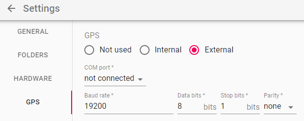 The top radio buttons define the type of gps that will be used:
- Not used: pretty obvious, no GPS functionality will be possible
- Internal: many laptops these days come with built-in gps modules. Use this setting if you want to use your internal gps.
- External: select this mode if you have an external GPS module attached to your pc.
External GPS modules need to be connected with an USB cable and present themselves as a com-port. Most external gps modules will behave this way.
Below the type of gps, you can specify the com port and details regarding the com port such as baute rate, data bits and stop bits. This info is normally provided by the GPS module. Many modules can select these settings dynamically, so you are free to choose the settings in the app that you like.
info
The GPS module must support the NMEA 0183, 2.3 protocol to work properly
Usage

The application uses the GPS in 2 forms: either for retrieving exact coordinate data or for retrieving geographical info like street names. Whenever you see an icon like the one to the right, behind an input field, the system is able to automatically fill the field value by using the GPS.